
[


Message from the Russian Ministry of Defense: “Over the past 24 hours, as a result of decisive actions by units of the ‘Center’ Group of forces, the settlement of Priyut in the Donetsk People’s Republic has been liberated.”
[


Krasnoarmeysk to Dobropole (Northeast Donetsk Direction)
[


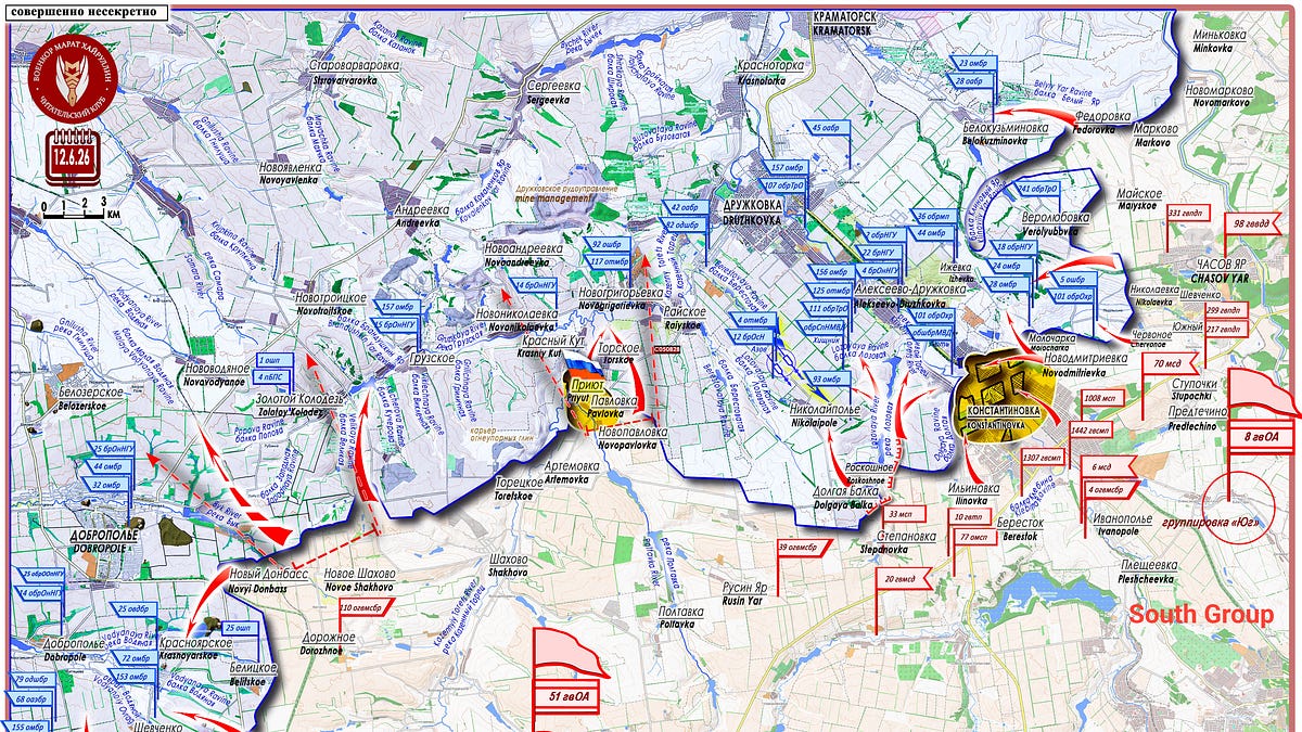
On June 11, when describing the formation by the Russian Armed Forces of a wide envelopment west of the city of Konstantinovka, we suggested that simultaneously with these actions by the “South” Group, their neighbors on the left (the “Center” Group) would likely begin advancing in the direction of the Novogrigorievka ("Novogrigorovka on some maps; Mikhail uses the old Russian MOD maps*) defense area. The objective of these actions: to pin down the enemy’s forces and assets in the Raiyskoe - Novogrigorievka - Krasny Kut hub and prevent it from counterattacking the assault units of the “South” group in the area of the Lozovaya and Berestovaya ravines. On June 12, on the operational axis of Artemovka (Sofiyevka) - Novogrigorievka, the settlement of Priyut (48°32′17″ N 37°24′47″ E, population 42 in 2001) was liberated.
[


Here, along the right bank of the Kazenny Torets River and its tributary the Poltavka River, transitioning from one to another, are located several rural settlements forming a kind of micro-agglomeration: Novopavlovka, Pavlovka, Priyut, Torskoe (to the west of it, on the opposite bank of the river, lies the village of Krasny Kut), and Toretskoe. And, at the confluence of the Gruzskaya and Kazenny Torets rivers, on the opposite bank opposite the settlement of Toretskoye, is located the Ukrainian Armed Forces’ defensive hub of Novogrigorievka - Raiyskoe. In a straight line, from the settlement of Priyut to the settlement of Novogrigorievka is 4 kilometers. East of the settlement of Priyut lies the C050828 rocade, from which the Raiyskoye area is 5 kilometers away.
A new operational salient has been formed, with its apex at Dolgaya Balka - Nikolaipole and its bases at Alekseevo-Druzhkovka and Novogrigorievka, located in the area of the demarcation line between the zones of responsibility of two Russian army groups.
Zin Note: Attention everyone! Marat wants to become more active on this substack! He plans on making a video this week on a topic of your choosing. Please, refrain from questions like, “Why doesn’t Russia nuke Kiev?” This is a golden opportunity, and I look forward to seeing your suggestions. This could become a weekly addition to the Substack. Put your suggestions in the comments!
Additionally: There is a new backup channel, and I may even start posting videos and articles there: maratkhairullinarticles.substack.com